
WWII 1944 MASAWENG RIVER Huon Peninsula New Guinea Campaign 5th Air Force Map For Sale

When you click on links to various merchants on this site and make a purchase, this can result in this site earning a commission. Affiliate programs and affiliations include, but are not limited to, the eBay Partner Network.

WWII 1944 MASAWENG RIVER Huon Peninsula New Guinea Campaign 5th Air Force Map:
$765.00
Comes with a hand-signed C.O.A.
This rare and museum-grade WWII Pacific Theater combat operations map was used during the infamous New Guinea Campaign (1942-1945). New Guinea was an important strategic island to both the Allied and Japanese Imperial Forces during World War II. Located east of Indonesia and just north of Australia, between the Coral Sea and the South Pacific Ocean, New Guinea is the second-largest island in the world. For the Americans, New Guinea served as a strategic point in the second stage of their offensive against the Japanese at Rabaul on the southwest Pacific Island of New Britain.
The New Guinea offensives were the single largest series of connected operations Australia and Allied forces in the Pacific have ever mounted. While the supreme command was, of course, American, and while the campaign depended upon American air and naval support, the New Guinea battles were Australia’s own. They involved tens of thousands of troops, both in combatant units and in the massive logistic infrastructure that jungle warfare demanded. From 1942 to August 1945, New Guinea was the location of some of the most infamous land, air, and naval battles in the Pacific Theater. It was here where US, Australian, British, and Netherlands soldiers fought against the Empire of Japanese. From 1942 to 1945 it is estimated that nearly 42,000 total Allied soldiers were KIA and 202,100 were KIA for Japan (127,600 on New Guinea\'s main island, 44,000 on Bougainville, 30,500 on New Britain, New Ireland, and the Admiralty Island).
Titled “MASAWENG RIVER WEST - NEW GUINEA” this combat map is a rare “1943 print created using aerial recon photos from the U.S. 8th Photo Squadron, 5th Air Force.
This incredibly rare and museum-grade WWII combat map was used during the Huon Peninsula campaign (New Guinea). The Huon Peninsula campaign was a series of battles fought in north-eastern Papua New Guinea in 1943–1944 during the Second World War. The campaign formed the initial part of an offensive that the Allies launched in the Pacific in late 1943 and resulted in the Japanese being pushed north from Lae to Sio on the northern coast of New Guinea over the course of a four-month period. For the Australians, a significant advantage was gained through the technological edge that Allied industry had achieved over the Japanese by this phase of the war, while the Japanese were hampered by a lack of supplies and reinforcements due to Allied interdiction efforts at sea and in the air.
Related Items:
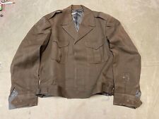
ORIGINAL WWII US ARMY OFFICER M1944 CLASS A IKE JACKET- MEDIUM/LARGE 42R
$183.96
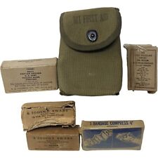
Vintage Authentic 1944 WWII Medical Field Kit
$90.78
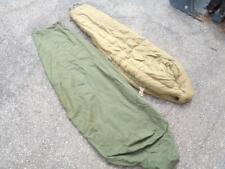
Vintage WWII US Military 1942 Mountain Down Sleeping Bag w/ 27-C-123 1944 Cover
$99.99