
1900 Sketch Map of 1710 Partial World Map by Herman Moll English Geographer For Sale

When you click on links to various merchants on this site and make a purchase, this can result in this site earning a commission. Affiliate programs and affiliations include, but are not limited to, the eBay Partner Network.

1900 Sketch Map of 1710 Partial World Map by Herman Moll English Geographer:
$37.00
Army Engineering This map/diagram was removed from a historical bound book of maps and documents, Government Printing Office. GPOMeasures about 9in x 9in.(Item #4182)Please check out our store MEMAPS for thousands of Antique Original Foldout Maps, Diagrams, and Plates including, Canals - Dikes - Rivers - Lakes - Harbors - Dredging -Flood Control - Concrete Piers - Dams Levees - Forests - National Parks - Railroads - Military Ordnance - Naval - Nautical - Topographical - Geographical - Mining - Tunnels - Bridges - Architectural Engineering - Reservations U.S.Territories - Wharfs – U.S Army Corps of Engineers Surveys.We offer a 100% satisfaction guarantee on all purchases.
Related Items:

Antique Male Portrait Sketch Early 1900s Cabinet Card Young Man Fancy Suit
$15.95
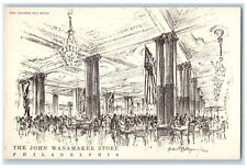
c1900 Sketch Tea Room John Wanamaker Stone Philadelphia Pennsylvania PA Postcard
$29.95
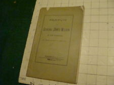
Vintage Original: 1900 SKETCH - GENERAL JAMES WILSON of New Hampshire by Briggs
$29.95