
1964 COLORADO Official State Highway Road Map Aspen Denver Pueblo Maroon Bells For Sale

When you click on links to various merchants on this site and make a purchase, this can result in this site earning a commission. Affiliate programs and affiliations include, but are not limited to, the eBay Partner Network.

1964 COLORADO Official State Highway Road Map Aspen Denver Pueblo Maroon Bells:
$12.99
Handsomefold-out 1964 official highway map of Colorado, printed more than 56 yearsago.
- This map opens to a very generous 34" x22" and has great detail on old road alignments.
- There are inset plansof Denver, Colorado Springs, and Pueblo.
- Among the other named places on the map are Boulder, Cripple Creek, LaJunta, Cortez, Alamosa, Grand Junction, Walsenburg, Greeley, FortCollins, Breckenridge, Broadmoor, Estes Park, Durango, Gunnison,Sterling, Paonia, and many more.
- It was published by the Colorado Department of Highways, Denver, in1964.
- The front cover photograph shows Maroon Lake and theMaroon Bells, near Aspen.
- Condition: This map is in excellent condition,bright and clean, with no marks, rips, or tears. Pleasesee the scans and feel free to ask any questions.
- Buy with confidence! We arealways happy to combineshipping onthe purchase of multiple items — just make sure to pay for everythingat one time, not by SixBit's eCommerce Solution
Related Items: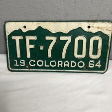
1964 Colorado License Plate Mountains #TF-7700
$19.78
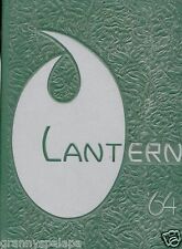
1964 Colorado Lutheran High School, Denver Colorado Yearbook - The Lantern
$39.00
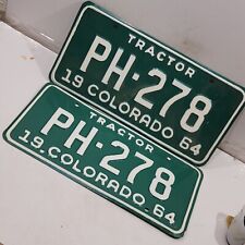
1964 Colorado License Plate Pair Tractor PH-278 man cave BAR
$37.28