Evidence supporting Kevin Mansfield's
Earth Formation Hypothesis.The Hypothesis:Earth, as we now know it, formed from the collision of two similarly sized planets, called Heaven and PreEarth. Heaven had a radius about ninety percent that of PreEarth. These two, initially comprised a binary system (just like the Earth and Moon presently comprise a binary system) orbiting the Sun.
Like a bullet rips through the skin of an apple, leaving most of the skin unscathed, Heaven crashed through the crust of PreEarth, taking most of its energy into the interior, while leaving much of the crust unscathed. Now, imagine that the mass of the apple and bullet are so large (planet sized) that the bullet cannot escape their combined gravity. Then you have the hypothesized situation. Of course, as PreEarth swallowed Heaven, it greatly expanded in size. This expansion, however, did not leave the remaining crust unscathed.
The Evidence:1) The hole in the Earth where the planet Heaven entered, i.e., the north west Pacific.Heaven impacted PreEarth in what is now the north west Pacific. As the map of the age of the sea-floor, below, shows, the impact area is very different from all other regions of sea-floor. This difference is to be expected as this area was the result of an impact, whereas, all other areas of ocean basin, including the southern and eastern Pacific, are the result of expansion. As expected, this region has no spreading ridges. The expansion and west to east spin of Heaven, ripped America away from the edge of the impact zone and Europe/Africa/Asia from America, creating new sea-floor in between. This same spin dragged molten material from under the eastern edge of the continent of Asia, and even the edge of Asia itself, into the western impact area, covering about a third of the area.
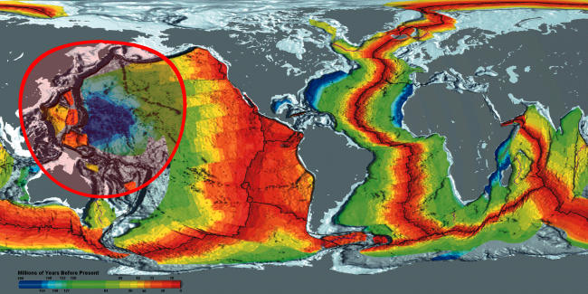
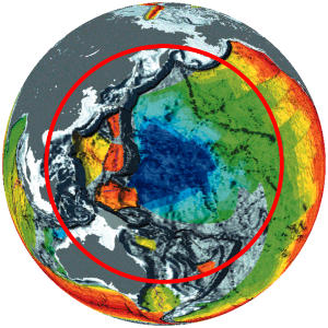
The map of Earth on the left, below, shows the impact zone as viewed from space.
 2) The impact mountains around the Pacific Ocean, i.e., the ring of fire.
The impact mountains must have initially formed a complete circle. This was broken up and rearranged by the expansion and spin, giving us the ring of fire as we know it today. Starting with the mountainous islands of the Philippines and Japan, the impact mountains then traverse Kamchatka, gap to Alaska, from whence they stretch right to the bottom of South America before continuing as the Antarctic Peninsula mountains. Their exact whereabouts from there is unclear, as the region has been extensively rearranged by the impact, however, they probably continue from the Antarctic Peninsula mountains, to the Southern Alps of New Zealand, the Colville and Kermadec ridges and then gap back to the Philippines, completing the circle. The map on the right, above, shows the positions of the impact mountains on a reconstructed PreEarth.
3) Western impact mountains ripped off continental block.The west to east spin of Heaven ripped sections of the impact mountains off the Asian continental block, which were then expanded hundreds of kilometers away, leaving seas in between. Japan and the Philippines are examples of this. Australia and New Zealand have also been ripped eastward with New Zealand having been ripped off the Australian block.
4) The impact caused continental drift.The impact destroyed a circular region of the Earth's crust (a spherical cap) about half the size of the hemisphere it hit. The crust within this cap was smashed into the interior. Clearly, the unimpacted crust formed a sphere minus this spherical cap. The expansion below the unimpacted crust, caused it to crack into what we now call continents. Further expansion, expanded these continents apart, in what is officially termed, continental drift.
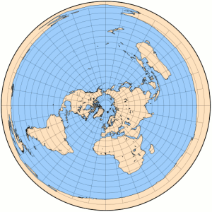
Using an azimuthal equidistant projection, we can map PreEarth to a circular flat map. If we choose the origin of the projection to be the antipode of the center of the impacted region, then we get the map on the left, below. The impacted region has been mapped into the outer ring around the circumference of the map and the unimpacted region into the circular region within that ring. We will call the region enclosed by the inner circle, i.e., the unimpacted region, PreEarth-Pangaea.

 5) The theory predicts a single circular continent with splits, i.e., Pangaea.
The expansion cracked PreEarth's unimpacted crust into large pieces that became today's continents. These massive pieces of crust largely retained their shape throughout the expansion, although their curvature changed considerably. Since these pieces of crust had previously comprised the region, PreEarth-Pangaea, it is clear that Earth's continents should be able to be shuffled about Earth's surface and be reassembled as an area resembling PreEarth-Pangaea. Of course, it will not be possible to recreate PreEarth-Pangaea, exactly, because of the change of curvature.
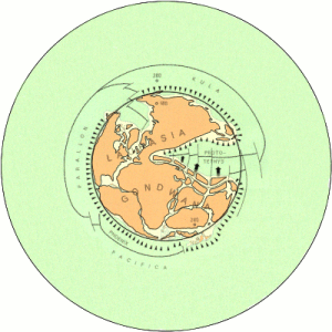
Alfred Wegener was the first to notice this and reassemble all of Earth's continents. Wegener patched them into a single landmass, which he called Pangaea. He claimed that Pangaea existed for millions of years, until, for some unknown reason, it broke into smaller continents, which then drifted to their current positions. Above, on the right, is a map of the Earth showing Pangaea (the land area enclosed by the inner circle). The azimuthal equidistant projection has been used to create this map which is from the America Association of Petroleum Geologists, and is, reportedly, the most accurate available.
If one took the crust from the PreEarth-Pangaea region and imposed Earth's curvature upon it, by say, placing it above the Earth and physically forcing it down until it lay on the Earth's surface, then the crust would necessarily split in one or two places and at least one of these splits would extend to the center of the region. This is exactly what we see in Wegener's Pangaea. The splits being the polar sea and the large triangular shaped Tethys Ocean, which extends right to the center of the region.
Of course, Pangaea never existed as a continent. It was never surrounded by ocean and the Tethys Ocean and polar sea never existed at all. These are understandable fictions, forced upon scientists because they reassembled Earth's continents on Earth, rather than on PreEarth, from whence the continents actually originated. However, even though these are fictional, they are all fictions predicted by the hypothesis.
To give you a better feel for the map projection used above, here is the azimuthal equidistant projection of Earth, with origin being the north pole (i.e., the antipode of the south pole). As you can see, the distortion at the south pole is maximal. The map on the right is the map of Pangaea from above, with color and a few more features.
 6) The theory predicts oceanic crust very different from continental crust.
Earth's continental crust is original PreEarth crust, whereas, oceanic crust is a mixture of material from both Heaven and PreEarth. Thus, one would expect oceanic crust to be noticeably different from continental crust. This is indeed the case.
Continental crust is composed of granitic rock (65% silica and 2.7 g/cm^3), whereas, oceanic crust is composed of basaltic rock (45% silica and heavier at 3.3 g/cm^3). Continental crust is believed to be up to 4 billion years old, whereas, oceanic crust is believed to be less than 200 million years. Oceanic crust averages about 8 kms in thickness, whereas, continental crust averages about 40 kms, etc, etc.
So, here is a theory that explains the genesis of Earth's continental crust, why its chemical composition is different to oceanic crust, why it dates much older and why they are of such different thicknesses. No current theory explains how continental crust came to be, let alone why it is so different from oceanic crust.
7) Warren Carey's evidence, is also evidence for this hypothesis.Right till the end of his life, in 2002, the renowned Australian geologist S. Warren Carey insisted that the geological evidence clearly demonstrated that the Earth had expanded. Carey considered many explanations for this expansion, but never considered the possibility of a large impact (probably because he believed the splitting of Pangaea took place over millions of years). Over his career, Carey collected a large body of evidence for his "expanding Earth theory." Since, Mansfield's theory is an expanding Earth theory, most of Carey's evidence is also evidence for his theory.
8) Apparent sea-floor ages explained as geochemical gradient due to mixing.Suppose, Heaven was involved in a catastrophic collision, in which the entire silicate rock layer was exploded away from the planet. Then, the impact would have melted and scattered its silicate rock, causing it to lose most of its Argon 40 (Ar40) to space. As the rump iron core of Heaven reconstituted its mantle by gathering these Ar40 depleted rocks in further collisions, even more argon would be lost and Heaven's new mantle would have almost no Ar40, while PreEarth's mantle would still have its full complement. So, when Heaven impacted PreEarth, we would expect to find argon gradients depending on the degree of mixing of their mantles. That is, there should be argon gradients between areas where the Earth's mantle was a well-mixed combination of Heaven and PreEarth's mantles and areas where it wasn't.
Thus, in the expansion of the oceans, we would expect that the oceanic crust of the continental margins would be mainly from PreEarth's mantle, as only partial mixing of the mantles would have occurred at this stage. Consequently, the continental margins would be richer in Ar40 and have a greater apparent age. As we proceed further from the continents the material forming the oceanic crust will have a progressively larger percentage of Heaven's mantle mixed in, and thus, date progressively younger. Similarly, one expects the material that closed over the impact area, to be mainly PreEarth's mantle, and thus date older.
So, the argon gradient used to date the sea-floor, can be interpreted as a geochemical gradient, one which can be explained by the mixing of materials with different initial argon concentrations. Anyway, if the Atlantic opened in a matter of hours, then clearly the usual methods of dating the sea floor are well off the mark.
9) The theory predicts Earth's core is rotating faster than its mantle.When the planets collided, obviously their outer layers impacted first. Thus, the outer layers sustained a large change in angular momentum as their spins clashed. However, this change was not transmitted, in full, to lower layers, as there was slippage at layer boundaries, in particular, the mantle-core boundary. So, in the first moments of the collision, the mantles would have been slowed relative to the cores. The fusion of the cores would not change this, and thus, the Earth acquired a core that rotated faster than its mantle. This prediction of the theory, has been known to be true since 1996, when Richards and Song found that the inner core spins about 20 kms/yr further than the mantle above it (this was revised down to about 8 kms/yr in 2005). Only the collision hypothesis explains why the Earth's inner core spins faster than the rest of the planet. One suspects that this extra spin of the core is the source of Earth's relatively strong magnetic field.
10) The theory predicts Earth's magnetic field is rapidly decreasing.Even though the inner core is spinning in the liquid of the outer core, friction will gradually slow it until it spins at the same rate as the mantle. If the extra spin of the core is really the source of Earth's magnetic field, then this would imply that the magnetic field is decaying. Apparently, this is the case. The Earth's magnetic field has been measured to be decaying at about five percent per century. Since this cannot be denied, the problem of the magnetic field decaying to zero, is largely ignored, or brushed off, with the claim that on becoming weak the field will reverse and recover its strength, just like it has many times before.
11) The theory predicts/explains magnetic reversals.As the two metallic cores fused, their combined magnetic field must have been in a state of extreme flux. The planetary fusion probably took less than a day and many reversals of magnetic polarity must have been experienced within this period. These reversals were recorded in the basalt of the expanding sea floors, as distinctive stripped patterns of magnetism. It is a fact that this magnetic signature is mostly from the top 400 meters of the basalt. For this 400 meter layer to have recorded the swiftly changing magnetic field, it must have cooled to below the Curie temperature, very rapidly. This rapid cooling was due to the new lava being immersed in the water of the oceans. This cooling, was not just a surface effect, as cracks and faults allowed the water to percolate to great depths.
12) The theory allows the force of gravity to have been smaller in the past.There is a large amount of indirect evidence that the Earth's gravity is now greater than it once was. For example, pterosaurs, such as hatzegopteryx, had wingspans of over thirteen meters and large, solidly constructed heads, making it a great puzzle as to how they flew, or even if they flew. Similarly, it is not known why the larger dinosaurs such as, argentinasaurus, did not collapse under their own weight. It is also unknown, how the gigantic bird, argentavis magnificens, with a mass of seventy kilograms and a wingspan of seven meters, managed to fly, when an albatross, with a mass of only nine kilograms and a wingspan of three meters, finds it difficult to get off the ground. Of course, if gravity was once significantly less, then maybe all this can be explained.
13) Removes the thermal catastrophe.Radiogenic heating rates for the mantle, range from 6 TW (based on direct measurements of the abundance of radioactive elements in the mid-ocean ridge basalts) to 13 TW (based on cosmochemical abundances (and more recently, anti-neutrino observations)). This implies a secular cooling rate between 23 and 30 TW. This rate of secular cooling is problematic, for when combined with quite reasonable models of mantle convection, it implies the mantle was molten some one or two billion years ago (the so called thermal catastrophe). The collision hypothesis removes this problem by placing a significant thermal event, i.e, the collision, within the last billion, or so, years.
14) The theory provides a decent power source for continental drift.The thermal catastrophe shows that the theory of mantle currents indirectly contradicts certain measured quantities. However, it is still accepted as the power source for continental drift, because "What other option is there?" Of course, the collision hypothesis now provides another option for the power source of continental drift.
This power source that moves continents thousands of kilometers and raises the Himalayas to great heights is "radioactive shine," that is, heat from the radioactive decay of material that is much less radioactive than you, or your surroundings. In fact, a segment of the Earth stretching 6371 kilometers from a point at the center, to a one meter square at the surface, generates only 0.08 watts of heat (with radiogenic heat from the mantle comprising about 30% of this total). This is about one ten thousandth the power of sunlight on a dull day. It is true that if you let "radioactive shine," shine for a few hundred million years, it adds up to a lot of energy, and much more so, if you let sunshine, shine for a few hundred million years. To use this, widely distributed, extremely dilute power, you have to first, stop it from escaping, then, concentrate it where the work will be done. We are told that the Earth and mantle currents can do this, but some doubt it.
15) Animations of the expansion plus drift can be produced.Animations have been produced, that trace the movement of the continents from the PreEarth-Pangaea region to todays arrangement. Each step of the animation preserves continental areas. This is strong evidence that one is on the right track.
16) Provides a new theory regarding the formation of the Moon.Suppose, a catastrophic collision between Heaven and a large object, blasted Heaven's entire silicate rock layer into an extensive debris field, leaving its iron core as the largest remnant. Further collisions with the debris would lead to the rump iron core gathering a new mantle and cascading ever closer to PreEarth. The debris field beyond Heaven's reach, would also accumulate, creating a new satellite of low density, poor in volatiles, and lacking an iron core, namely, the Moon as we know it today. Among other things, this scenario would explain why the oxygen-17/oxygen-18 ratio of the lunar samples is indistinguishable from the terrestrial ratio. It would not explain the age of the lunar rocks.
A brief history of the ideas.Many of the ideas above were first presented in a public lecture, on November 2, 2008, at the Alexandra Park Raceway, Auckland, New Zealand. They were subsequently written up and published, on April 20, 2010, in the form of a 26 page paper. The preprint server arxiv.org refused to distribute this paper (clearly, the task of releasing preprints to the scientific community should be taken from those at arxiv.org and given to some responsible party). Consequently, toward the end of May, the website
www.preearth.net was established to publicize the paper. This summary of evidence was completed on July 29, 2010.
Kevin Mansfield, has a BSc(Hons) from the University of Auckland (Auckland, New Zealand) and a PhD in mathematics from the University of New South Wales (Sydney, Australia). He may be contacted by;
Forum:http://www.preearth.net/phpBB3/viewtopic.php?f=2&t=34Email: preearth7@yahoo.com
From:
Evidence supporting Mansfield's Earth Formation Hypothesis.Expanding on point 15.
15) Animations of the expansion plus drift can be produced.The opening of the Atlantic.

The opening around Antarctica.

The opening of the South Atlantic.

The opening of the Indian Ocean.
http://preearth.net/anim-indian-ocean-400.gif
The opening around Australia.
http://preearth.net/anim-australia-400.gif
The opening around India.
http://preearth.net/anim-india-400.gif
Notice that India is pushed under the rest of Asia, forming the Himalayas.
Cool animations, eh?
From; http://www.preearth.net/animations.html


